1.什么是GeoTools?
Geotools是一个java类库,它提供了很多的标准类和方法来处理空间数据,同时这个类库是构建在OGC标准之上的,是OGC思想的一种实现。而OGC是国际标准,所以geotools将来必定会成为开源空间数据处理的主要工具,目前的大部分开源软件,如udig,geoserver等,对空间数据的处理都是由geotools来做支撑。而其他很多的web服务,命令行工具和桌面程序都可以由geotools来实现。
主要特性
Geotools主要提供各种GIS算法,实现各种数据格式的读写和显示。
在显示方面要差一些,只是用Swing实现了地图的简单查看和操作。
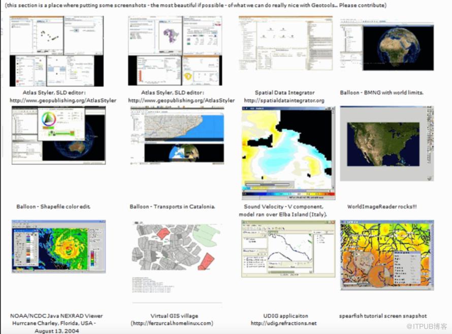
用户可以根据Geotools提供的算法自己实现地图的可视化。OpenJump和udig就是基于Geotools的。
目前的大部分开源软件,如udig,geoserver等,对空间数据的处理都是由geotools来做支撑。
web服务,命令行工具和桌面程序都可以由geotools来实现。
是构建在OGC标准之上的,是OGC思想的一种实现。而OGC是国际标准,所以geotools将来必定会成为开源空间数据处理的主要工具,
Geotools用到的两个较重要的开源GIS工具包是JTS和GeoAPI。前者主要是实现各种GIS拓扑算法[只是图形与图形的九交模型并不是图层或图层间的拓扑算法],也是基于GeoAPI的。
Geotools现在还只是基于2D图形的,缺乏对 3D空间数据算法和显示的支持。
Geotools支持的数据格式
arcsde, arcgrid, geotiff, grassraster, gtopo30, image(JPEG, TIFF, GIF, PNG), imageio-ext-gdal, imagemoasaic, imagepyramid, JP2K,matlab;
支持的数据库“jdbc-ng”:db2, h2, mysql, oracle, postgis, spatialite, sqlserver;
支持的矢量格式和数据访问:app-schema, arcsde, csv, dxf, edigeo, excel, geojson,org, property, shapefile, wfs;
XML绑定。基于xml的Java数据结构和绑定提供了如下格式xsd-core (xml simple types), fes,filter, gml2, gml3, kml, ows, sld, wcs, wfs, wms, wps, vpf。对于额外的geometry、sld和filter的编码和解析可以通过dom和sax程序。
支持大部分的OGC标准
OGC中的sld/SE和渲染引擎;
OGC一般要素模型包括简单要素支持;
OGC中栅格信息的网格影像表达;
OGC中WFS,WMS和额外的WPS;
ISO 19107 geometry规范;
Geotools依赖的开源项目
JTS:JTS是加拿大的 Vivid Solutions 做的一套开放源码的 Java API。它提供了一套空间数据操作的核心算法,为在兼容OGC标准的空间对象模型中进行基础的几何操作提供2D空间谓词API。
GeoAPI:GeoAPI为OpenGIS规范提供一组Java接口。
GeoTools的方向
2.代码工程
实验目的:实现geotools读取.shp文件
pom.xml
<?xml version="1.0" encoding="UTF-8"?><project xmlns="http://maven.apache.org/POM/4.0.0"xmlns:xsi="http://www.w3.org/2001/XMLSchema-instance"xsi:schemaLocation="http://maven.apache.org/POM/4.0.0 http://maven.apache.org/xsd/maven-4.0.0.xsd"><parent><artifactId>springboot-demo</artifactId><groupId>com.et</groupId><version>1.0-SNAPSHOT</version></parent><modelVersion>4.0.0</modelVersion><artifactId>GeoTools</artifactId><properties><maven.compiler.source>8</maven.compiler.source><maven.compiler.target>8</maven.compiler.target><geotools.version>20.0</geotools.version></properties><dependencies><dependency><groupId>org.springframework.boot</groupId><artifactId>spring-boot-starter-web</artifactId></dependency><dependency><groupId>org.springframework.boot</groupId><artifactId>spring-boot-autoconfigure</artifactId></dependency><dependency><groupId>org.springframework.boot</groupId><artifactId>spring-boot-starter-test</artifactId><scope>test</scope></dependency><!-- 添加GeoTools依赖 --><dependency><groupId>org.geotools</groupId><artifactId>gt-shapefile</artifactId><version>${geotools.version}</version></dependency><dependency><groupId>org.geotools</groupId><artifactId>gt-swing</artifactId><version>${geotools.version}</version></dependency><!-- wkt转geojson --><dependency><groupId>org.geotools</groupId><artifactId>gt-geojson</artifactId><version>${geotools.version}</version></dependency></dependencies><repositories><repository><id>osgeo</id><name>OSGeo Release Repository</name><url>https://repo.osgeo.org/repository/release/</url><snapshots><enabled>false</enabled></snapshots><releases><enabled>true</enabled></releases></repository><repository><id>osgeo-snapshot</id><name>OSGeo Snapshot Repository</name><url>https://repo.osgeo.org/repository/snapshot/</url><snapshots><enabled>true</enabled></snapshots><releases><enabled>false</enabled></releases></repository></repositories></project>
controller
package com.et.geotools.controller;import com.et.geotools.pojos.ShpInfo;import com.et.geotools.result.ResponseResult;import com.et.geotools.service.ShpService;import org.springframework.beans.factory.annotation.Autowired;import org.springframework.web.bind.annotation.*;import javax.servlet.http.HttpServletResponse;@CrossOrigin@RequestMapping("/shper")@RestControllerpublic class ShpController {@Autowiredprivate ShpService shpService;@GetMapping("/hello")public String sayHello(){return "Hello Appleyk's Controller !";}/*** 写一个shp文件* @param shpInfo* @return* @throws Exception*/@PostMapping("/write")public ResponseResult write(@RequestBody ShpInfo shpInfo) throws Exception{return shpService.writeShp(shpInfo);}/*** 查询一个shp文件* @param shpFilePath 文件绝对路径* @param limit 指定显示多少条shp特征【features】* @return* @throws Exception*/@GetMapping("/query")public ResponseResult query(@RequestParam(value = "path",required = true) String shpFilePath,@RequestParam(value = "limit",required = false,defaultValue = "10") Integer limit ) throws Exception{return shpService.getShpDatas(shpFilePath,limit);}/*** 将shp文件转换成png图片,图片或写入文件或通过response输出到界面【比如,客户端浏览器】* @param path shp文件路径* @param imagePath 如果imagePath不等于空,则shp文件转成图片文件存储进行存* @param color 渲染颜色*/@GetMapping("/show")public void show(@RequestParam(value = "path",required = true) String path,@RequestParam(value = "imagePath",required = false) String imagePath,@RequestParam(value = "color",required = false) String color,HttpServletResponse response) throws Exception{// 设置响应消息的类型response.setContentType("image/png");// 设置页面不缓存response.setHeader("Cache-Control", "no-cache");response.setHeader("Pragma", "no-cache");response.setDateHeader("Expires", 0);shpService.showShp(path, imagePath,color ,response);}}
service
package com.et.geotools.service;import com.et.geotools.geotools.ShpTools;import com.et.geotools.pojos.ShpDatas;import com.et.geotools.pojos.ShpInfo;import com.et.geotools.result.ResponseMessage;import com.et.geotools.result.ResponseResult;import org.springframework.stereotype.Service;import javax.servlet.http.HttpServletResponse;@Servicepublic class ShpService {public ResponseResult getShpDatas(String shpPath, Integer limit) throws Exception{ShpDatas shpDatas = ShpTools.readShpByPath(shpPath, limit);return new ResponseResult(ResponseMessage.OK,shpDatas);}public void showShp(String shpPath,String imagePath,String color, HttpServletResponse response) throws Exception{ShpTools.shp2Image(shpPath, imagePath ,color,response);}public ResponseResult writeShp(ShpInfo shpInfo) throws Exception{return ShpTools.writeShpByGeom(shpInfo);}}
util
package com.et.geotools.geotools;import com.et.geotools.IO.StringTokenReader;import com.et.geotools.pojos.ShpDatas;import com.et.geotools.pojos.ShpInfo;import com.et.geotools.result.ResponseMessage;import com.et.geotools.result.ResponseResult;import org.geotools.data.*;import org.geotools.data.shapefile.ShapefileDataStore;import org.geotools.data.shapefile.ShapefileDataStoreFactory;import org.geotools.data.simple.SimpleFeatureSource;import org.geotools.feature.FeatureCollection;import org.geotools.feature.FeatureIterator;import org.geotools.feature.simple.SimpleFeatureTypeBuilder;import org.geotools.geometry.jts.ReferencedEnvelope;import org.geotools.map.FeatureLayer;import org.geotools.map.Layer;import org.geotools.map.MapContent;import org.geotools.referencing.crs.DefaultGeographicCRS;import org.geotools.renderer.lite.StreamingRenderer;import org.geotools.styling.SLD;import org.geotools.styling.Style;import org.geotools.swing.JMapFrame;import org.geotools.swing.data.JFileDataStoreChooser;import org.locationtech.jts.geom.Point;import org.locationtech.jts.geom.Polygon;import org.locationtech.jts.geom.*;import org.opengis.feature.Property;import org.opengis.feature.simple.SimpleFeature;import org.opengis.feature.simple.SimpleFeatureType;import org.springframework.util.ResourceUtils;import javax.imageio.ImageIO;import javax.servlet.http.HttpServletResponse;import java.awt.*;import java.awt.image.BufferedImage;import java.io.File;import java.io.IOException;import java.io.Serializable;import java.nio.charset.Charset;import java.nio.charset.StandardCharsets;import java.text.SimpleDateFormat;import java.util.Collection;import java.util.HashMap;import java.util.Map;public class ShpTools {/**几何对象构造器【自定义的】*/private static GeometryCreator gCreator = GeometryCreator.getInstance();/**边界*/private static ReferencedEnvelope bounds;/**画布的宽度*/private static final int IMAGE_WIDTH = 1280;/**画布的高度*/private static final int IMAGE_HEIGHT = 1200;/*** 通过shp文件路径,读取shp内容* @param filePath 文件路径*/public static ShpDatas readShpByPath(String filePath, Integer limit) throws Exception {// 一个数据存储实现,允许从Shapefiles读取和写入ShapefileDataStore shpDataStore = new ShapefileDataStore(new File(filePath).toURI().toURL());// 设置编码【防止中文乱码】shpDataStore.setCharset(StandardCharsets.UTF_8);// getTypeNames:获取所有地理图层,这里我只取第一个【如果是数据表,取出的就是表名】String typeName = shpDataStore.getTypeNames()[0];System.out.println("shp【图层】名称:"+typeName);FeatureCollection<SimpleFeatureType, SimpleFeature> result = getFeatures(shpDataStore, typeName);// 迭代特征集合FeatureIterator<SimpleFeature> iterator = result.features();ShpDatas shpDatas = new ShpDatas();shpDatas.setName(typeName);shpDatas.setShpPath(filePath);buildShpDatas(limit, iterator, shpDatas);iterator.close();return shpDatas;}/*** 根据数据源及图层名称拿到特征集合* @param shpDataStore shp数据存储对象* @param typeName 图层名称* @return FeatureCollection*/private static FeatureCollection<SimpleFeatureType, SimpleFeature> getFeatures(ShapefileDataStore shpDataStore, String typeName) throws IOException {// 通过此接口可以引用单个shapefile、数据库表等。与数据存储进行比较和约束FeatureSource<SimpleFeatureType, SimpleFeature> featureSource = shpDataStore.getFeatureSource(typeName);// 一个用于处理FeatureCollection的实用工具类。提供一个获取FeatureCollection实例的机制FeatureCollection<SimpleFeatureType, SimpleFeature> result = featureSource.getFeatures();System.out.println("地理要素【记录】:"+result.size()+"个");System.out.println("==================================");return result;}/*** 构建shpDatas对象* @param limit 要素查询限制数* @param iterator 迭代器* @param shpDatas shp封装的数据集*/private static void buildShpDatas(Integer limit, FeatureIterator<SimpleFeature> iterator, ShpDatas shpDatas) {// 这里我们只迭代前limit个int stop = 0;while (iterator.hasNext()) {if (stop > limit) {break;}// 拿到一个特征SimpleFeature feature = iterator.next();// 取出特征里面的属性集合Collection<Property> p = feature.getProperties();// 遍历属性集合Map<String,Object> prop = new HashMap<>();for (Property pro : p) {String key = pro.getName().toString();String val;if ("java.util.Date".equals(pro.getType().getBinding().getName())){SimpleDateFormat dateFormat = new SimpleDateFormat("yyyy/MM/dd");val = pro.getValue() ==null ? "" : dateFormat.format(pro.getValue());}else{val = pro.getValue()==null ?"":pro.getValue().toString();}prop.put(key, val);System.out.println("key【字段】:"+key+"\t||value【值】:"+val);}System.out.println("\n============================ 序号:"+stop+"\n");shpDatas.addProp(prop);stop++;} // end 最外层 while}/*** 将一个几何对象写进shapefile* @param filePath 文件路径* @param geometry 几何对象*/public static void writeShpByGeom(String filePath, Geometry geometry) throws Exception{ShapefileDataStore ds = getshpDS(filePath, geometry);FeatureWriter<SimpleFeatureType, SimpleFeature> writer = ds.getFeatureWriter(ds.getTypeNames()[0],Transaction.AUTO_COMMIT);// Interface SimpleFeature:一个由固定列表值以已知顺序组成的SimpleFeatureType实例。SimpleFeature feature = writer.next();feature.setAttribute("name", "XXXX名称");feature.setAttribute("path", "c:/test");feature.setAttribute("the_geom", geometry);feature.setAttribute("id", 1010L);feature.setAttribute("des", "XXXX描述");System.out.println("========= 写入【"+geometry.getGeometryType()+"】成功 !=========");// 写入writer.write();// 关闭writer.close();// 释放资源ds.dispose();}/*** 将一个几何对象写进shapefile* @param shpInfo shp信息*/public static ResponseResult writeShpByGeom(ShpInfo shpInfo) throws Exception{// 特殊字符串解析器StringTokenReader reader = new StringTokenReader();// 根据几何对象的wkt字符串,反解【解析】成Geometry对象Geometry geometry = reader.read(shpInfo.getGeom());// 拿到shp对象所在的目录【文件夹】String path = shpInfo.getPath();File file = new File(path);if(!file.exists()){file.mkdir();}if(!file.isDirectory()){return new ResponseResult(ResponseMessage.BAD_REQUEST,"path不是有效的文件夹" );}String filePath = shpInfo.getPath()+"/"+shpInfo.getName()+".shp";ShapefileDataStore ds = getshpDS(filePath, geometry);String typeName = ds.getTypeNames()[0];FeatureWriter<SimpleFeatureType, SimpleFeature> writer ;if(shpInfo.isAppendWrite()){// 追加写几何对象writer = ds.getFeatureWriterAppend(typeName, Transaction.AUTO_COMMIT);}else{// 覆盖写几何对象writer = ds.getFeatureWriter(typeName, Transaction.AUTO_COMMIT);}// Interface SimpleFeature:一个由固定列表值以已知顺序组成的SimpleFeatureType实例。SimpleFeature feature = writer.next();feature.setAttribute("name", shpInfo.getName());feature.setAttribute("path", shpInfo.getPath());feature.setAttribute("the_geom", geometry);feature.setAttribute("id", shpInfo.getId());feature.setAttribute("des", shpInfo.getDes());System.out.println("========= 写入【"+geometry.getGeometryType()+"】成功 !=========");// 写入writer.write();// 关闭writer.close();// 释放资源ds.dispose();// 返回创建成功后的shp文件路径return new ResponseResult(ResponseMessage.OK,filePath);}/*** 拿到配置好的DataStore* @param filePath 文件路径* @param geometry 几何对象* @return ShapefileDataStore*/private static ShapefileDataStore getshpDS(String filePath, Geometry geometry) throws IOException {// 1.创建shape文件对象File file = new File(filePath);Map<String, Serializable> params = new HashMap<>();// 2、用于捕获参数需求的数据类 URLP:url to the .shp file.params.put(ShapefileDataStoreFactory.URLP.key, file.toURI().toURL());// 3、创建一个新的数据存储【如果存在,则不创建】ShapefileDataStore ds = (ShapefileDataStore) new ShapefileDataStoreFactory().createNewDataStore(params);// 4、定义图形信息和属性信息 -- SimpleFeatureTypeBuilder 构造简单特性类型的构造器SimpleFeatureTypeBuilder tBuilder = new SimpleFeatureTypeBuilder();// 5、设置 -- WGS84:一个二维地理坐标参考系统,使用WGS84数据tBuilder.setCRS(DefaultGeographicCRS.WGS84);tBuilder.setName("shapefile");// 添加名称tBuilder.add("name", String.class);// 添加shp所在目录名称tBuilder.add("path", String.class);// 添加 一个几何对象tBuilder.add("the_geom", geometry.getClass());// 添加一个idtBuilder.add("id", Long.class);// 添加描述tBuilder.add("des", String.class);// 设置此数据存储的特征类型ds.createSchema(tBuilder.buildFeatureType());// 设置编码ds.setCharset(StandardCharsets.UTF_8);return ds;}/*** 打开shp文件,获取地图内容* @param filePath 文件路径* @param isOpenByChoose 是否自定义打开shp文件* @throws Exception*/public static MapContent getMapContentByPath(String filePath,boolean isOpenByChoose,String color) throws Exception{File file;if(isOpenByChoose){// 1.1、 数据源选择 shp扩展类型的file = JFileDataStoreChooser.showOpenFile("shp", null);}else{// 1.2、根据路径拿到文件对象file = new File(filePath);}if(file==null){return null;}// 2、得到打开的文件的数据源FileDataStore store = FileDataStoreFinder.getDataStore(file);// 3、设置数据源的编码,防止中文乱码((ShapefileDataStore)store).setCharset(Charset.forName("UTF-8"));/*** 使用FeatureSource管理要素数据* 使用Style(SLD)管理样式* 使用Layer管理显示* 使用MapContent管理所有地图相关信息*/// 4、以java对象的方式访问地理信息 -- 简单地理要素SimpleFeatureSource featureSource = store.getFeatureSource();bounds = featureSource.getBounds();// 5、创建映射内容,并将我们的shapfile添加进去MapContent mapContent = new MapContent();// 6、设置容器的标题mapContent.setTitle("Appleyk's GeoTools");Color color1;if(color == null || "".equals(color.toLowerCase())){color1 = Color.BLACK;}else if("red".equals(color.toLowerCase())){color1 = Color.RED;}else if("green".equals(color.toLowerCase())){color1 = Color.GREEN;}else if("blue".equals(color.toLowerCase())){color1 = Color.BLUE;}else{color1 = Color.getColor(color);}// 7、创建简单样式 【颜色填充】Style style = SLD.createSimpleStyle(featureSource.getSchema(),color1);// 8、显示【shapfile地理信息+样式】Layer layer = new FeatureLayer(featureSource, style);// 9、将显示添加进map容器mapContent.addLayer(layer);return mapContent;}public static void showMap(MapContent mapContent){JMapFrame.showMap(mapContent);}/*** shp文件转Image【格式定png】* @param shpFilePath shp目标文件* @param destImagePath 转成图片的文件 == 如果没有,转成的图片写进response输出流里* @param response 响应流* @throws Exception*/public static void shp2Image(String shpFilePath,String destImagePath,String color, HttpServletResponse response) throws Exception{// 流渲染器StreamingRenderer renderer = new StreamingRenderer();MapContent mapContent = getMapContentByPath(shpFilePath,false,color );renderer.setMapContent(mapContent);Rectangle imageBounds = new Rectangle(0, 0, IMAGE_WIDTH, IMAGE_HEIGHT);BufferedImage dumpImage = new BufferedImage(IMAGE_WIDTH, IMAGE_HEIGHT, BufferedImage.TYPE_INT_RGB);Graphics2D g2d = dumpImage.createGraphics();g2d.fillRect(0, 0, IMAGE_WIDTH, IMAGE_HEIGHT);g2d.setRenderingHint(RenderingHints.KEY_ANTIALIASING, RenderingHints.VALUE_ANTIALIAS_ON);renderer.paint(g2d, imageBounds, bounds);g2d.dispose();if(destImagePath == null || "".equals(destImagePath)){ImageIO.write(dumpImage, "png", response.getOutputStream());}else{ImageIO.write(dumpImage, "png", new File(destImagePath));}}public static void main(String[] args) throws Exception{File file = ResourceUtils.getFile("classpath:static/shpTest[Point]/dp_tl.shp");// 从shp文件里面读取属性信息readShpByPath(file.getAbsolutePath(),10);System.out.println("=================下面开始往shp文件里面写几何对象===================");// 先创建文件夹testString filePath = "C:/test/test.shp";String pointWkt="POINT (120.76164848270959 31.22001141278534)";Point point = gCreator.createPointByWKT(pointWkt);// Polygon【面】String polygonWkt="POLYGON ((103.859188 34.695908, 103.85661 34.693788, 103.862027 34.69259, 103.863709 34.695078, 103.859188 34.695908))";Polygon polygon = gCreator.createPolygonByWKT(polygonWkt);// LineString【线】String linestringWkt="LINESTRING(113.511315990174 41.7274734296674,113.51492087909 41.7284983348307,113.516079593384 41.727649586406,113.515907932007 41.7262243043929,113.514019656861 41.7247989907606,113.512131381714 41.7250872589898,113.51138036319 41.7256637915682,113.511315990174 41.7274734296674)";LineString lineString = gCreator.createLineByWKT(linestringWkt);// MultiPolygon【多面】String multiPolyWkt = "MULTIPOLYGON(((101.870371 25.19228,101.873633 25.188183,101.880564 25.184416,101.886808 25.186028,101.892043 25.189969,101.896592 25.190163,101.903716 25.190785,101.905454 25.193464,101.899897 25.196202,101.894146 25.197911,101.891657 25.19826,101.886078 25.197658,101.884211145538 25.2007060137013,101.88172564506 25.1949712942389,101.87874 25.199619,101.874641 25.200998,101.868547 25.202415,101.863741 25.202415,101.85887 25.202842,101.854557 25.202182,101.852604 25.199736,101.852282 25.19628,101.854492 25.194183,101.855608 25.192668,101.863698 25.192105,101.870371 25.19228)))";MultiPolygon multiPolygon = gCreator.createMulPolygonByWKT(multiPolyWkt);// 几何对象的范围【矩形边界】Envelope envelope = polygon.getEnvelopeInternal();System.out.println(envelope);// 往shp文件里面写几何对象writeShpByGeom(filePath,point);}}
application.properties
server.port=8081server.servlet.session.timeout=10server.tomcat.uri-encoding=utf8
以上只是一些关键代码,所有代码请参见下面代码仓库
代码仓库
https://github.com/Harries/springboot-demo
3.测试
启动spring boot应用
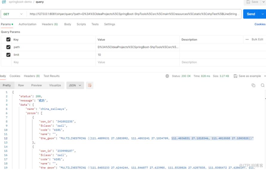
测试查看shp文件
shp转换成图片

4.引用
https://docs.geotools.org/latest/userguide/geotools.html
http://www.liuhaihua.cn/archives/710655.html
原文作者:HBLOG;如有侵权,请联系管理员删除。

