高德地图和google地图适配
今天介绍的是大型app必备模块-地图模块。
当今世界最大的地图sdk应该是google地图,但是由于国内墙掉了google play service,国内是无法使用google地图的,然而国内比较热门的地图sdk是高德地图和百度地图。(如果你是IOS,还有自带的地图)
近来项目中需要世界地图,所以特此做了一个高德地图和google地图兼容的模块了。
Sdk接入
1.google地图,接入相对比较简单,当然因为Android本身就是google亲儿子的原因。
需要引入google service的sdk,以及google map的sdk
https://developers.google.com/places/android-api/start,获取账号需要gmail邮箱作为管理
2.高德地图接入相对比较复杂一点,可以选择2d,3d,定位,搜索多种模块去接入地图。
然后需要申请账号,随便邮箱手机号就可以了,通过keytools命令提出keystore的sha1值,包名和
sha1值相互绑定的,每次请求都会验证。
然后配置AndroidManifest中的meta-data。
预览模块
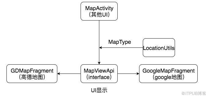
1.高德地图是通过sdk提供的com.amap.api.maps2d.MapView自定义地图View来实现的。
google地图是通过sdk提供一个Fragment空间来实现地图获取
mapFragment = childFragmentManager.findFragmentById(R.id.google_map) as SupportMapFragment
2.地图预览
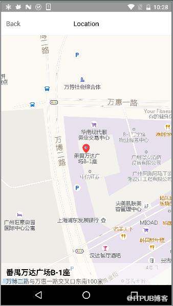
Google地图和高德地图接口相关的名字都是差不多的,比较常用的接口
moveCamera 视窗转移 缩放级别分为1~17级,数值越大地图越精准
addMarker 添加地图标签
google地图是使用getMapAysnc,会有onMapReady的接口回调
        mapFragment?.getMapAsync(this)    /**
     * 地图就绪
     */
    override fun onMapReady(googleMap: GoogleMap?) {
        googleMap ?: return
        with(googleMap) {
            val latLng = LatLng(latitude, longitude)            //视觉转移
            moveCamera(CameraUpdateFactory.newLatLngZoom(latLng, 16f))            //添加坐标
            addMarker(MarkerOptions().position(latLng))
        }
    }
高德地图使用setOnMapLoadedListener方法来设置回调
aMap?.setOnMapLoadedListener {            //视觉移动
            aMap?.moveCamera(CameraUpdateFactory.newLatLngZoom(LatLng(latitude, longitude), 100f))            //添加坐标
            aMap?.addMarker(MarkerOptions().anchor(0.5f, 0.5f)
                    .icon(BitmapDescriptorFactory
                            .fromBitmap(BitmapFactory.decodeResource(
                                    resources, R.drawable.common_drag_location)))
                    .position(LatLng(latitude, longitude)))
        }
如果不想地图的坐标和视觉点显示居中怎么办?
需要将布局中margin上着手,如果想要往上移,就需要将marginTop设置为负值,这样地图中心点就会上移动,并且视觉点也会和中心点一样上移。
定位模块
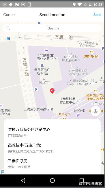
1.高德提供了AMapLocationListener作为专为提供高德坐标的监听
      private fun setUpMap() {
        myLocationStyle = MyLocationStyle()
        myLocationStyle?.strokeColor(Color.argb(0, 0, 0, 0))// 设置圆形的边框颜色
        myLocationStyle?.radiusFillColor(Color.argb(0, 0, 0, 0))// 设置圆形的填充颜色
        myLocationStyle?.myLocationIcon(BitmapDescriptorFactory.fromResource(R.drawable.common_self_location))  //显示自身定位坐标
        aMap?.setMyLocationStyle(myLocationStyle)
        aMap?.isMyLocationEnabled = true// 设置为true表示显示定位层并可触发定位,false表示隐藏定位层并不可触发定位,默认是false
        val uriSettings = aMap?.uiSettings
        uriSettings?.isZoomControlsEnabled = false //关掉缩放键
    }    private fun initLoc() {        //初始化定位
        mLocationClient = AMapLocationClient(context!!.applicationContext)        //设置定位回调监听
        mLocationClient?.setLocationListener(this)        //初始化定位参数
        mLocationOption = AMapLocationClientOption()        //设置定位模式为高精度模式,Battery_Saving为低功耗模式,Device_Sensors是仅设备模式
        mLocationOption?.locationMode = AMapLocationClientOption.AMapLocationMode.Hight_Accuracy        //设置是否返回地址信息(默认返回地址信息)
        mLocationOption?.isNeedAddress = true
        //设置是否只定位一次,默认为false
        mLocationOption?.isOnceLocation = false
        //设置是否强制刷新WIFI,默认为强制刷新
        mLocationOption?.isWifiActiveScan = false
        //设置是否允许模拟位置,默认为false,不允许模拟位置
        mLocationOption?.isMockEnable = false
        //设置定位间隔,单位毫秒,默认为3000ms
        mLocationOption?.interval = (3000)        //给定位客户端对象设置定位参数
        mLocationClient?.setLocationOption(mLocationOption)        //启动定位
        mLocationClient?.startLocation()
    } override fun onLocationChanged(amapLocation: AMapLocation?) {       //监听实时定位
    }
google的定位是使用Android原生的Location定位
locationManager = context!!.getSystemService(Context.LOCATION_SERVICE) as LocationManager
locationManager?.requestLocationUpdates(LocationManager.GPS_PROVIDER, 3000, 10f, this)
            locationManager?.requestLocationUpdates(LocationManager.NETWORK_PROVIDER, 3000, 10f, this)
 /**
  *地图就绪
   */
    override fun onMapReady(googleMap: GoogleMap?) {
        googleMap ?: return
        this.googleMap = googleMap        with(googleMap.uiSettings) {
            isZoomGesturesEnabled = true
            isMyLocationButtonEnabled = true
            isScrollGesturesEnabled = true
        }        try {
            googleMap.isMyLocationEnabled = true
        } catch (e: SecurityException) {
            ALog.e(TAG, e)
        }
   }   /**
     * 定位更新
     */
    override fun onLocationChanged(location: Location?) {

    }
搜索模块
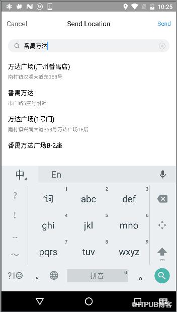
1.google 搜索有两种方式,一种是通过webapi来搜索出附近相关的地点(这里使用了RxVolley的框架),这个的好处关联结果比较多。
这里不用Uri.Builder的拼接方式是因为其指定了Utf-8的格式转换将会出现“,”强转为“%”号
val googlePlaceUrl = "https://maps.googleapis.com/maps/api/place/nearbysearch/json" fun getGoogleNearByPlaces(latitude: Double, longitude: Double, radius: Int): Observable{ val builder = StringBuilder(googlePlaceUrl) builder.append("?location=").append(latitude.toString()).append(",").append(longitude.toString()) builder.append("&radius=").append(radius.toString()) builder.append("&key=").append(googlePlaceKey) return RxVolley.get (builder.toString(), null, object : TypeToken () {}.type) }
第二种是文字关联搜索(
这边是使用了需要高级定义搜索,所以使用了Adapter的形式。
    override fun doSearch(key: String, city: String?) {
        Observable.create(ObservableOnSubscribe> {
            it.onNext(getAutocomplete(key)!!) //需要在次线程
        }).subscribeOn(Schedulers.io())
                .observeOn(AndroidSchedulers.mainThread())
                .subscribe({
                    searchAdpater?.clearData()                    for (item in it) {
                        val placeResult = mGeoDataClient!!.getPlaceById(item.placeId)
                        placeResult.addOnCompleteListener(mUpdatePlaceDetailsCallback)  //异步访问单个placeId的详细信息
                    }
                }, {
                    ALog.e(TAG, it)
                })
    }    /**
     * 异步访问单个placeId的详细信息
     */
    val mUpdatePlaceDetailsCallback = object : OnCompleteListener {        override fun onComplete(task: Task) {            try {
                val place = task.result.get(0)
                searchAdpater?.addData(LocationItem(false, place.latLng.latitude, place.latLng.longitude, place.name.toString(), place.address.toString()))
                ALog.i(TAG, "Place details received: " + place.name)
                task.result.release()
            } catch (e: RuntimeRemoteException) {
                ALog.e(TAG, e)
            }
        }
    }private fun getAutocomplete(constraint: CharSequence): ArrayList? {
        ALog.d(TAG, "Starting autocomplete query for: " + constraint)        // Submit the query to the autocomplete API and retrieve a PendingResult that will
        // contain the results when the query completes.
        val results = mGeoDataClient?.getAutocompletePredictions(constraint.toString(), null,                null)        // This method should have been called off the main UI thread. Block and wait for at most
        // 60s for a result from the API.
        //收集文字关联预测结果
        try {
            Tasks.await(results!!, 2, TimeUnit.SECONDS)
        } catch (e: ExecutionException) {
            e.printStackTrace()
        } catch (e: InterruptedException) {
            e.printStackTrace()
        } catch (e: TimeoutException) {
            e.printStackTrace()
        }        try {
            val autocompletePredictions = results!!.result

            ALog.d(TAG, "Query completed. Received " + autocompletePredictions.count
                    + " predictions.")            // Freeze the results immutable representation that can be stored safely.
            return DataBufferUtils.freezeAndClose(autocompletePredictions)
        } catch (e: RuntimeExecutionException) {            // If the query did not complete successfully return null
            Toast.makeText(context, "Error contacting API: " + e.toString(),
                    Toast.LENGTH_SHORT).show()
            ALog.e(TAG, "Error getting autocomplete prediction API call", e)            return null
        }

    }
2.高德地图中的PoiSearch是支持通过关键字搜索和经纬度地址附近搜索。
    /**
     * 经纬度搜索
     */
    fun doSearchQuery(city: String, latitude: Double, longtitude: Double) {
        query = PoiSearch.Query("", "", city) // 第一个参数表示搜索字符串,第二个参数表示poi搜索类型,第三个参数表示poi搜索区域(空字符串代表全国)
        query?.pageSize = 20 // 设置每页最多返回多少条poiitem
        query?.pageNum = 1  // 设置查第一页
        val poiSearch = PoiSearch(context, query)
        poiSearch.setOnPoiSearchListener(onPoiSearchListener)        // 设置搜索区域为以lp点为圆心,其周围5000米范围
        poiSearch.bound = PoiSearch.SearchBound(LatLonPoint(latitude, longtitude), 1000, true)
        poiSearch.searchPOIAsyn()  // 异步搜索
    }    /**
     * 关键字搜索
     */
    fun doSearchQuery(keyWord: String, city: String?) {        if (city != null)
            query = PoiSearch.Query(keyWord, "", city)        else
            query = PoiSearch.Query(keyWord, "", "")
        query?.pageSize = 20 // 设置每页最多返回多少条poiitem
        query?.pageNum = 1  // 设置查第一页

        val poiSearch = PoiSearch(context!!, query)
        poiSearch.setOnPoiSearchListener(onSearchListener)
        poiSearch.searchPOIAsyn()  // 异步搜索
    }
当然也支持异步返回
    /**
     * 搜索结果
     */
    val onSearchListener = object : PoiSearch.OnPoiSearchListener {        override fun onPoiSearched(result: PoiResult?, rCode: Int) {            if (rCode == 1000) {                if (result?.query!! == query) {                    //返回结果列表
                    result.pois
                }
            }
        }        override fun onPoiItemSearched(p0: PoiItem?, p1: Int) {               //返回再搜索
        }
    }
地图缩略图获取
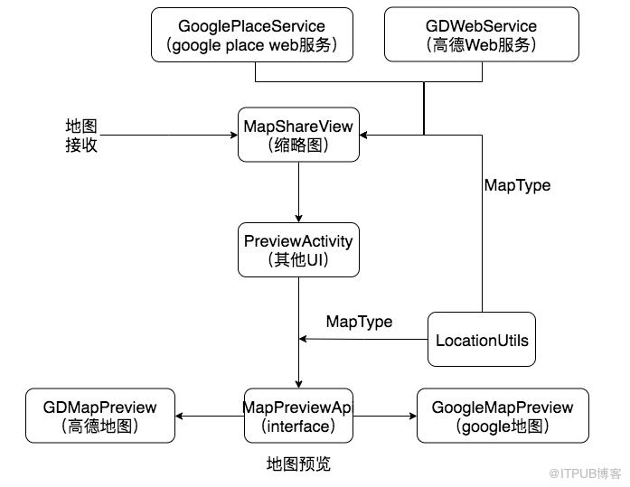
1.高德地图和google地图都需要使用web api来获取缩略图
        var builder: StringBuilder? = null
        if (type == GDMAP) {
            builder = StringBuilder(gdImgUrl)
            builder.append("?location=").append(longitude).append(",").append(latitude)
            builder.append("&zoom=").append(zoom)
            builder.append("&size=").append(dpToPx(context, width)).append("*").append(dpToPx(context, height))
            builder.append("&markers=").append("mid").append(",").append(",A:").append(longitude).append(",").append(latitude)
            builder.append("&key=").append(gdMapKey)
        } else if (type == GOOGLEMAP) {
            builder = StringBuilder(googleImgeUrl)
            builder.append("?center=").append(latitude).append(",").append(longitude)
            builder.append("&zoom=").append(zoom)
            builder.append("&size=").append(dpToPx(context, width)).append("x").append(dpToPx(context, height))
            builder.append("&markers=").append(latitude).append(",").append(longitude)
            builder.append("&key=").append(googlePlaceKey)
        }        return builder.toString()
这里需要注意的是
来自 “ ITPUB博客 ” ,链接:https://blog.itpub.net/1052/viewspace-2806086/ ,如需转载,请注明出处,否则将追究法律责任。

